| Milton, VT Weather by Bob DeVarney | |||
|---|---|---|---|
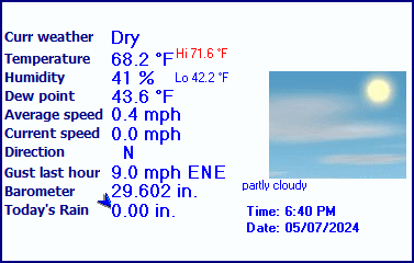
| LAST READING AT TIME: 5:50 PM DATE: April 26 2024, time of next update: 6:00 pm | |||
| Current Weather | Dry | Current Temperature | 58.8°F (14.9°C), Apparent temp 56.7°F |
| Maximum Temperature (since midnight) | 60.5°F at: 5:12 PM | Minimum Temperature (since midnight) | 24.0°F at: 5:17 AM |
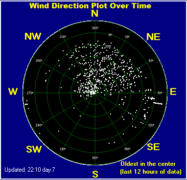
| Average windspeed (ten minute) | 0.7 mph | Wind Direction (ten minute) | NE (47°) |
| Windchill Temperature | 58.8°F | Maximum Gust (last hour) | 4.0 mph at: 5:12 PM |
| Maximum Gust (since midnight) | 11.5 mph at: 2:09 PM | Maximum 1 minute average (since midnight) | 6.7 mph at: 1:41 PM |
| Rainfall (last hour) | 0.00 in. (0.0 mm) | Rainfall (since midnight) | 0.00 in. (0.0 mm) --- |
| Rainfall This month | 1.94 in. (49.3 mm) | Rainfall To date this year | 5.12 in. (130.0 mm) |
| Maximum rain per minute (last hour) | 0.00 in/min | Maximum rain per hour (last 6 hours) | 0.00 in/hour |
| Yesterdays rainfall | 0.00 in | DewPoint | 26.6°F (Wet Bulb :46.0°F ) |
| Humidity | 29 %, Humidex 53.7°F | Barometer corrected to msl | 30.347 in. (1027.7 hPa) |
| Pressure change | -0.00 in. (last hour) | Trend (last hour) | STEADY |
| Pressure change (last 12 hours) | -0.03 in | Pressure change (last 6 hours) | -0.05 in |
| Current Indoor Temp. 70.6°F | |||
| Current Indoor Hum. 27% | |||


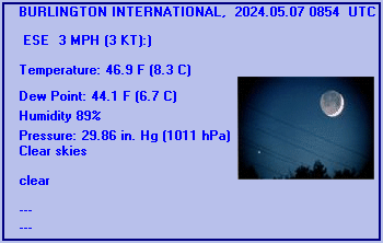
BURLINGTON INTERNATIONAL, VT, United States (KBTV) 44-28N 73-09W 105M
Apr 26, 2024 - 03:54 PM EDT / 2024.04.26 1954 UTC
Wind: from the NNW (330 degrees) at 10 MPH (9 KT) (direction variable):0
Visibility: 10 mile(s):0
Sky conditions: mostly clear
Temperature: 57.0 F (13.9 C)
Dew Point: 19.9 F (-6.7 C)
Relative Humidity: 23%
Pressure (altimeter): 30.46 in. Hg (1031 hPa)
ob: KBTV 261954Z 33009KT 300V360 10SM FEW100 14/M07 A3046 RMK AO2 SLP317 T01391067
cycle: 20
Use the RELOAD facility on your browser to retrieve the latest data.